|
Click To Enlarge
 |  |  |  |  |
 |  |  |  |  |
Overview
Rino 650 combines a 5 W FRS/GMRS radio with a 2.6" glove-friendly color touchscreen GPS packed full of powerful features like a barometric altimeter, 3-axis electronic compass and NOAA weather radio.
Pinpoint Your Position
With its high-sensitivity GPS receiver and quad helix antenna, Rino 650 quickly finds your position and maintains it – even in heavy cover. Plus, a built-in barometric altimeter and 3-axis compass make it easy to get your bearings without the need to hold it level.
See Your Surroundings
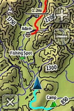
The device comes with a worldwide basemap with shaded relief, so you can navigate anywhere with ease. Adding more maps is easy with Garmin's wide array of detailed topographic, marine and road maps. With its microSD™ card slot, Rino 650 lets you load TOPO U.S. 24K maps and hit the trail or plug inBlueChart® g2 preloaded cards for a great day on the water. The device also supports BirdsEye Satellite Imagery (subscription required), that lets you download satellite images to your device and integrate them with your maps. In addition, Rino 650 is compatible with Custom Maps, free software that transforms paper and electronic maps into downloadable maps for your device.
Find Your Friends
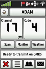
Rino 650’s unique Position Reporting capability lets you send your exact location to other Rino users so they can see it on their map page. Plus, improved audio performance means it’s easy to communicate with any other conventional FRS/GMRS radio in the area. It can be useful in an emergency, or just a handy way to keep tabs on your hunting party, hiking partner, family or friends.
Stay in Touch
With plenty of transmit power, Rino 650 also lets you send unit-to-unit text messages to other Rino users in your area – it's ideal for loud or windy conditions, or just when you don't want to disturb the wildlife. It also lets you share your waypoints, tracks, routes and geocaches wirelessly with other compatible Garmin handheld devices.
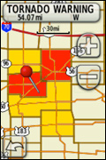
View Weather Watches and Warnings
For added safety, Rino 650 features a built-in NOAA weather radio that can help you avoid hazardous weather. The radio supports Specific Area Message Encoding, which allows you to see National Weather Service warnings and watches displayed county-by-county on the map screen.
Plan Your Next Trip
Take charge of your next adventure with BaseCamp™, software that lets you view and organize maps, waypoints, routes, and tracks. This free trip-planning software even allows you to create Garmin Adventures that you can share with friends, family or fellow explorers. BaseCamp displays topographic map data in 2-D or 3-D on your computer screen, including contour lines and elevation profiles. It also can transfer an unlimited amount of satellite images to your device when paired with a BirdsEye Satellite Imagery subscription.
Turn Your Computer Into a Base Station
The all-new BaseStation lets you turn your laptop (loaded with BaseCamp) into a field command center for tracking multiple Rino units. View real-time GPS information on the larger display of your computer with Rino serving as a router/antenna. And because it’s Garmin GPS-based, safer, more effective search and rescue operations are in your control, even where Internet and cell phone service isn’t.
Features
 | Weathering the Storm
Weather any storm with Rino's built-in NOAA weather radio that helps you avoid hazardous weather. The radio displays county lines and storm watches/warnings on the map screen so you'll always be in the know...and safe.
|
Advanced Contact Tracking
What's in a name? A lot when it comes to Rino. Now, you can track 2,000 points of information per contact. Plus, the track manager makes it easy for you to maintain and review who you've been tracking.
| |
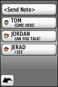 | Improved Notes
Gone are the days of missing a note. Rino time stamps and records the notes you receive from contacts for later review, or forwarding.
|
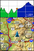 | Dashboards
Bring more functionality to your device with more dashboards in more places. View your elevation plot, coordinates, compass arrow and more on any page, at any time.
|
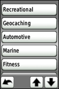 | Multiple Personalities with Multiple Profiles
Customize Rino to be as well-rounded as you. You can set up different profiles so you can quickly switch personalities based on what you're doing - hiking, driving or more. With Rino, you'll never miss a beat.
|
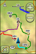 | View Multiple Contacts
Stay with your group, even when they are far away. Rino lets you view multiple contacts on 1 screen, so even if you're far away, you can see where they are in relation to you. Plus, you can easily route to your friends or regroup if you need to.
|
Rugged GPS + Radio
- Uses HotFix® and a high sensitivity receiver and quad helix antenna to acquire satellites
- Offers an improved base map with Digital Elevation Model
- Offers improved mapping support with access to TOPO U.S. 24K, BirdsEye Satellite Imagery, Garmin Custom Maps, City Navigator NT®, BlueChart® g2 and more (sold separately)
- Uses a universally accepted GPX file format to store your data and allow compatbility with your computer
- Offers innovative features like a 2.6" glove-friendly color touchscreen, barometric altimeter and 3-axis electronic compass
- Allows you to send unit-to-unit text messages (via radio signals) to other Rino users in the area as well as share your waypoints, tracks, routes and geocaches wirelessly
Specs
In the Box